Walksheds Visualized:Showing Population and Places of Workwithin Walking distance of Montreal Rail Stations
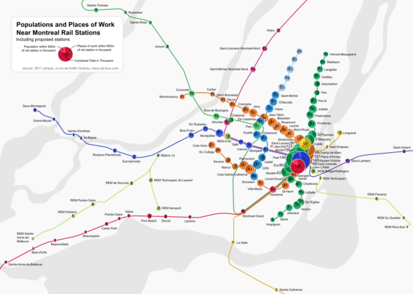
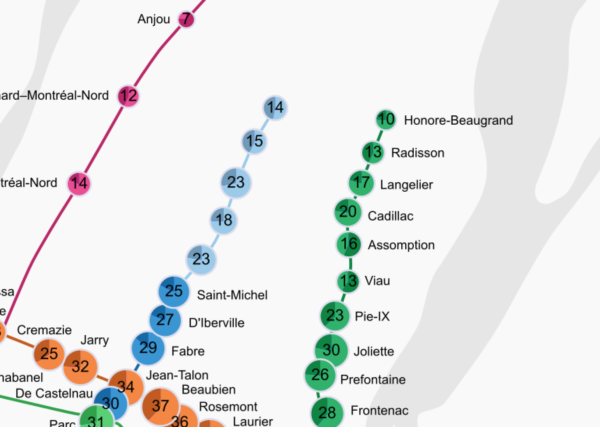
July 22nd, 2016 by ant6nA while back I published a map of Montreal showing the populations living within walking distance of rail stations in the region. At the time, many asked me to add places of work as well, and proposed new stations. Today I’m publishing a map that includes these, and I’ve made it look prettier as well.
The area that is reachable within walking distance of a station is called its walk-shed. The actual walking distance depends on the geometry of the street, and also on the person. Some are more willing to walk a longer distance than others. I picked the commonly used 800m or half a mile distance (as the bird flies) as a reasonable approximation.
The population data comes from the same census as the previous map (which is the most recent one we have), the work places are extracted from a census map as described here.
Note that in places where the stations are closer together, the walk-sheds will overlap. This is intentional, as I want to show the density just as much as an absolute number.
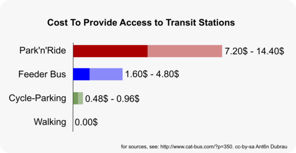
Every residence and every work place within walking distance of a train station is the potential beginning or end of a transit trip that does not require parking or a feeder bus. Both can be very expensive, and also make using transit less desirable. The system is most effective and most financially sustainable when as many people as possible live within walking distance of stations.
I tried to estimate the cost to provide feeder buses and parking in this previous post.
Here are some observations:
Downtown is insane
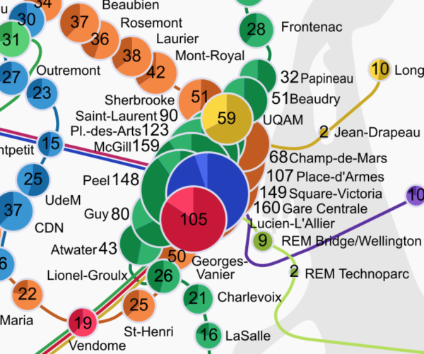
One thing I noticed when adding workplaces to the map is just how many people work downtown, and how important they are. When considering just population, Cote-Sainte-Catherine was the station with the most density around it, 28,000 people. Once you add in work places, the combined total reaches 160,000 for McGill and Gare Centrale. Those stations are incredible trip generators!
According to the STM’s data, McGill and Berri-UQAM are actually the busiest stations. I believe that the census data did not consider the universities as ‘places of work’ for students. So McGill, Concordia, Berri-UQAM and Udem possibly each have another several tens of thousand students nearby who are not accounted for in the census data.
Badly paced outlying stations
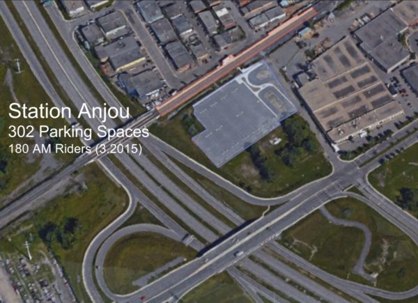
Another thing I realized is how bad some of the outlying stations are. One in particular is the Anjou station on the Mascouche line. I know there is a lot of population near that line in Montreal North and East, about as many as in the whole West Island (about 200,000 people). So why is the Anjou station doing so badly?
The answer can be found if you just look at it from above:
The stations is sandwiched between a highway, a large boulevard and a low-density industrial area. Basically the only thing within walking distance is a parking lot. The station was basically only designed for drivers coming in via the highway and using the park’n’ride. So its ridership can only ever be as large as the parking lot — that’s an ineffective use of space, money and transit; and focusing only on drivers is inequitable as well.
What about proposed stations?
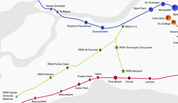
I’m a little bit concerned that the transit projects that we have in the pipeline right now don’t consider walkability enough. The Blue Line extension appears to do okay, about as well or maybe a bit better as the Eastern Branch of the Green line.
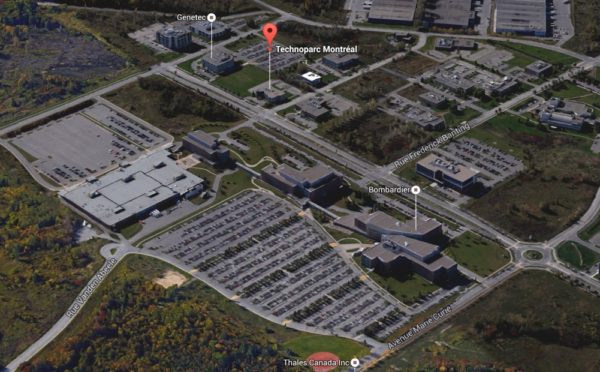
The REM stations on the other hand, being almost exclusively along highways, really don’t connect to much within walking distance. We hear how important the Technoparc Saint-Laurent is, with 7,000 workers — but if we compare that to the metro stations, it’s obvious that it’s really a small number.
Even stations in predominantly residential areas will have that many places of work, even though most of their surrounding area is for housing. And really, the Technoparc just a suburban office park, of supposedly ‘cleantech’ firms, but the area mostly consists of parking. In fact, if you work in one of those places, your car gets more space than you do:
The REM proposal also includes stations that are absolutely abysmal, like the Technopark Pointe-Sainte-Charles (2,000 workers). Moreover, the proposed station near Sainte-Anne-de-Bellevue is the only station with zero population and work places within walking distance in the whole Montreal region. At this point, it will mostly serve to induce sprawl.
There are proposals for some Transit Oriented Development, but since the corresponding are stations near highways, it will be difficult to build walkable neighborhoods from scratch. I really wish the 5.5 billion dollars in transit investment would result in better connections to existing neighborhoods.
Looking at all the data, it really makes me wish we would focus more on connecting to people within walking distance and making transit as effective as possible.

July 22nd, 2016 at 10:30
Very depressing reading. However, if one built in an accessibility-to-station index based on numbers and frequencies of feeder buses the situation is or could be a bit brighter. By the way, surely feeder buses can be counted as free. I agree of course that having to take a bus at all is an impediment. The only hope for the off-metro stations you cited is for more inspired bus feeder systems.
July 22nd, 2016 at 11:20
@David
Yes, feeder buses is the answer anywhere where density is low. But we could place the stations better nevertheless.
But feeder buses are not for free. Optimistically they cost about 30 cent per passenger kilometer to operate. So if you are 3km away from the station, that’s almost 2$ per day, or 40$ per month extra. Since the monthly pass is only about 87$, this means almost half of it goes towards the feeder buses – which in turn means the actual rail line, which aspires to be profitable, would not get enough money if revenue is evenly shared.
So in the end, in order for the REM to stay profitable as per the Caisse’s mandate, we will probably have to subsidize the buses more (we don’t get the cross-subsidies from the profitable but privatized rail line).
Feeders aren’t free – especially if the fed line does not cross-subsidize the feeders.
July 22nd, 2016 at 11:35
Of course. I was thinking of the perceived cost to the user excluding time valuation. It is to be hoped that private feeder bus services could be provided by the companies in the industrial zones, individually or collectively. or would they be illegal?
July 26th, 2016 at 11:38
Small error in the map: you swapped Beaconsfield and Beaurepaire.
You probably also know about this publication?
http://tram.mcgill.ca/Research/Publications/Transit_service_area.pdf
I think 1200m is indeed more appropriate for rail, and it may even be a bit higher in suburban settings (you walk faster if there isn’t a traffic light at every block). Anyway, with 1.2km you cover more than twice the area compared to 800m.
Personal experience: I live 600-750m from Cedar Park station (depending on the exit) and see people walking further. There is very limited parking there (28 spaces), and bike racks with 50 spaces that tends to be a quarter to half full. According to
https://www.amt.qc.ca/Media/Default/pdf/section8/amt-rapport-annuel-2015.pdf
there are 214,500 passengers per year or 400 per work day in one direction.
Downtown I also walk 800m from LuLa but on occassion walk further (e.g. 2km to places on McGill campus, still quicker than two metros from Vendome or the 107 in traffic + waiting).
July 26th, 2016 at 13:11
@CedarPark
Aw sucks. So annoying to fix an error like that.
You make a couple of good points re distance – But note that I picked 800m as the bird flies, which especially in suburban settings means on the ground you may have to walk much further. You also have to consider that people don’t have much of a choice in a suburban setting, the commuter rail is the only thing that’s available. But do consider the distance decay in the paper, not all that many people walk from more than a 1km (relative to the amount of area it represents).
It’s probably also true that when walking from a station to work, people aren’t willing to walk 800m a second time.
I mostly wanted to have a reasonable distance that is comparable across all the stops; we want to see the density near the stops more than measure the actual walk-shed population, and use that to illustrate whether they connect to a neighborhood well. But yes, it’s a simplification.
If you are near Cedar Park, would you walk to the proposed Fairview station? Is the possible reduction of service along the VH line a concern for somebody as yourself, or does the existence of more frequent transit service outweigh those concerns?
July 27th, 2016 at 09:24
The Fairview station is too far too walk at 3km (if an overpass or underpass is built for the 40; without that it’s even longer). I would consider cycling it, but most definitely the VH service is preferable for normal commute runs.
Presently I take the bus (211/405/411/485) when there is a large multi-hour gap in VH service, maybe a few times a month. This is usually not a big issue, except around 2:30pm when traffic on the 20 can already slow down buses quite a bit. I can’t predict whether the REM or the 211 would be more convenient on a late evening.
For people north of Stillview the story is quite different though.
I don’t see stations without much parking such as Cedar Park or Lachine getting a lot of competition from the REM. Mostly it’s those with large parking lots, mainly Beaconsfield and Pointe-Claire. Even then it depends: are the CDPQ parking lots free, how much space is available, etc.? Dorval has a largish free parking lot too, and I can’t imagine the CDPQ constructing a free parking lot at the airport station when airport parking costs $5/20 minutes!
July 27th, 2016 at 09:38
(I meant north of Sedgefield — if you live north of the Duke-of-Kent/Sedgefield area the 40 is closer than the 20). I must also add that if nothing else happens the area around the 20 is reasonably pedestrian and cyclist friendly with various bike paths, shortcuts, tunnels and overpasses, certainly by suburban standards, but the area around the 40 is downright hostile.
July 27th, 2016 at 09:43
You are so right about Anjou, this station is by the way so badly nammed.
It’s location is way closer to RDP citizens and way more useful to them than Angevins people (official name of Anjou’s citizens). But it is almost impossible to get there by bus and from RDP you must make big detours by car or on foot to get there as the streets on the north side grant no access to the station ; Henri-Bourassa is a “passage obligé”.
The closest residential Anjou area is the new dev around the half-artificial lake near Costco and Léon megastores but these are already close to Radisson (bus line Radisson ; in straight line) and eventually much closer to the projected blue line terminus. To them, a TRAM card is a waste of money. Actually, Anjou is more a RDP #2 train station with an underdevelopped access to the cégep nearby.
Even if it is officially in the northernmost part of Anjou, West-RDP or Marie-Victorin would be more practical names and it should mean an efficient access from both side of the tracts.
July 27th, 2016 at 09:44
*Bus line 44
July 27th, 2016 at 09:55
Pointe-Aux-Trembles is also poorly designed. Entering and exiting it might be really long, I experienced it once. If you are at the queue of the train, you have to walk the whole lenght of the platform to get to an equally long tunnel to go down dozens of stairs… And then if you are the unlucky guy who got the worst parking slot, you have to walk again the same distance along the tunnel and the platform.
Interrestingly, and like in your conclusion, a TOD project is supposed to be on the way and you can find the plan somewhere. Like the parking, these buildings will be also on the wrong side (as the other side is a protected natural habitat) This will highlight more the main mistake made when planning the station : placing the platform on the wrong side of the tracks with no way to pass over or under it. It as abnormal that when planning your moves you have to count so much time just to get in/out.
Let’s hope that the REM proposal will not compromise this TOD project.
July 27th, 2016 at 17:34
Where are you going to put these parking lots and how are people going to get at them on the congested north-south routes. The whole REM plan is so seriously vague that it begs the how. Should be scrapped..
July 27th, 2016 at 19:08
@Ron
Well, ideally a ‘metro’ line to the West Island should attempt to be as close to people as possible, so they can walk. Then you don’t need as many people to park’n’ride to the stations. And if the stations are directly on the corridors (as opposed to 1.3 km away from them), and there would be a station on all of the five potential north-south corridors, then we could have a frequent bus line on all of those corridors, which would provide a very short connection to the train.This could encourage more people to take a frequent feeder bus, again reducing the need for parking.
After all, parking is expensive, and it requires a lot of space, the less we need the better.
I’m a little bit concerned that for many people in the West Island, driving is such a normal aspect of life that considering walking/bus to a metro station feels like a downgrade, even if the alternatives are set up well.
Of course as long as we’re planning rapid transit along the a-40, then the discussion is moot, because there are few people within walking distance, and bus connections will be slow and awkward at best. Oh and I doubt REM parking will be free.
May 5th, 2017 at 11:13
Personnaly, i live in Laval-des-Rapides about 1.1 km south of Montmorency metro station. If i go to Montréal i will required a lift (aka a car/van ride from my dad ) to the Montmorency metro station but i will return home by walking around 15 minutes. I could also use the STL bus services but it goes only to the Cartier Metro Station which is 30 minutes walk away from my home. Since i’m 44 going to 45 in august . It’s cost 3,25$ for a 8 minutes ride (3,4 km). 0,96 $/km (0,83$/km) if i use bus ticket (22,50$/8 tickets). So I just use it when i just too tired to walk home or when it’s raining. My mom who just turns 80 years old in April just can walk in one shot to the corner of the street. Even she have free ride with the STL she will rarely take the bus. My father who is younger than my mom (73 in april too) rather use his van than take the bus in Laval. Even it is free because of the trunk capacity of his car. He only use the bus on special occasion like a show or a conference in Montréal where he does not need to carry heavy things and when parking is next to impossible to find or is very expensive.
November 16th, 2017 at 23:59
It would be cool to see this map with future pink line !
September 7th, 2018 at 15:25
I am a bit late with this discussion. An interesting analysis. I believe that you do not take into account the potential development impact of the stations.
Stations can service local populations as origins, yet they can also serve as destination hubs. The planning should allow for destination development as well. Since the trains have to return during rush hour, this will allow the trains to have a function for the return traffic. In turn this will improve the revenue stream.
With access to rapid transit, there are environments that will go for more intensive development, For example the Pointe Claire REM station has a large vacant lot adjacent to it. This site should be developed for back office projects integrated to the station The same could be said for the Sources station and the St Charles site (if Kirkland has a vision).
But this depends on the vision of the towns and their zoning by-laws. Developers prefer residential projects, they are easier to finance. Office development (while more profitable) takes longer. As a result I expect towns will be under considerable pressure to zone for residential development.