Archive for the ‘scheduling’ Category

Ottawa’s O‑Train (Part I):
a Little German Train in Canada

Friday, March 29th, 2013

Passengers at Carleton Station.

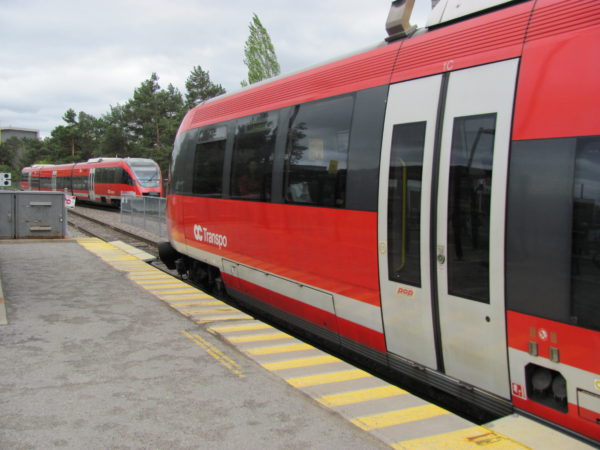
One a recent(ish) visit to Ottawa I got to visit one of it’s major attractions – the Ottawa O-Train! I had read about it before, a small project that transformed a short stretch of a freight railway into a transit line, using “Talent” Diesel Multiple Unit trains built by Bombardier. Using these trains is unusual in North America, because they do not fulfil the requirements of main line trains with respect to buff strength (basically they are too light). Although these trains are considered main line trains in Europe, in North America they are called “light rail”. The three Talents that OC Transpo uses for the O-Train were acquired out of an order by DB (Deutsche Bahn), which uses these trains on un-electrified regional rail lines.
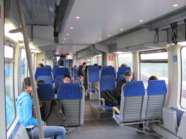
The interior of the O-Train should look familiar to people who have taken DB Regio trains

The interior of the O-Train should look familiar to people who have taken DB Regio trains. Note how the luggage racks were blocked off.

The arriving train came in a familiar color – the color scheme of DB and OC Transpo are so similar that the trains weren’t even repainted. The interior of the train felt strangely familiar as well, because it is all just the DB design. Having ridden many trains in Germany, I felt like I was sitting in piece of Europe in Canada. The ride is also unusally smooth by North American standards (I haven’t encountered too many rail vehicles with air suspension here).

Even the "Bitte druecken"-Button is original

Even the door opening button is still labelled “Bitte drücken” (please press).

If you like rail and transit, it’s easy to be a fan of the O-Train. But the real innovation of the O-Train is not the specific train that is used, but the transit planning of the line. It is easy to focus on a particular transit technology (in this case the DMUs), and overlook the transit line that is built with it. And some of of that planning was imported from Europe just like the trains themselves.

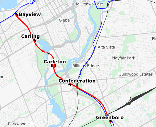
Overview of the O-train line. The blue lines are OC Transpo busways.

Overview of the O-train line. The blue lines are OC Transpo busways.

The O-Train is a short line established on a segment of an existing, infrequently used freight line corridor. Along it’s 7.8km length there are 5 stations. At both terminals passengers can transfer to busways. The station at the center, Carleton, provides access to the University, which is otherwise awkward to reach. The line is single tracked, except for the Carleton station, which has two tracks and two platforms. This allows two trains to run simultaneously, passing each other there. The trains take about 12 minutes to traverse the length of the line, and with a short turn-around time, this allows service with a headway of exactly 15 minutes.

The O-train is entirely single tracked.

The O-train line is entirely single tracked.

One train every fifteen minutes doesn’t sound very often by rapid transit standards, but one has to consider that the schedule is completely regular, the same every hour. The train leaves at :00, :15, :30, :45 and arrives twelve minutes later. This fixed interval schedule (or “Takftfahrplan” in the original German) allows people to easily remember the complete schedule, making the service more convenient even for less than regular riders.

Trains pass each other at Carleton Station, so two trains can run on the line at the same time

Trains pass each other at Carleton Station, so two trains can run on the line at the same time.

Another way in which the O-Train is more part of the transit network rather than a railroad in the traditional sense is the ticketing. Unlike many commuter railroads, the tickets are integrated with the surrounding rapid transit system, monthly passes are accepted, as well as day passes and transfers from buses. The line is viewed as part of the overall transit network, not some premium service. There are also no conductors aboard, and no turn-stiles either – the tickets are checked randomly, and there’s a fine for traveling without a valid ticket. This system, called Proof-of-Purchase (POP) is heavily used in Europe. It allows operation of the train with the vehicle operator only, no conductors required.

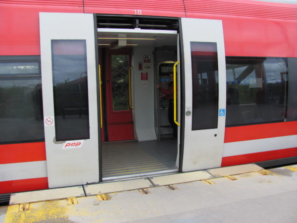
The 35m long platforms at the stations are level with the train entries. There are no steps into the train, and the doors are wide. Not only does this mean the train is easily accessible, it reduces the boarding and alighting time. Together with the reasonably fast acceleration of the DMUs (for example compared to diesel locomotive hauled trains), the resulting short dwell time allows the quick running time which again results in the relatively frequent schedule using only two trains.

Wide doors, Level Boarding

Wide doors, Level Boarding. Note the POP-sticker – that’ll remind ya 😉

The O-train started service in October 2001 as a pilot project to evaluate the Light Rail technologies for Ottawa. Although the specific technology was not chosen for other rail lines in Ottawa (the Confederation line will use electrified low floor LRTs), the line itself has earned its keep. After the first year, the ridership reached around 6200 passengers per day, 9500 by Fall 2004 and close to 14000 by September 2011. A 2005 report, updated in 2008 (pdf, also includes some of the ridership numbers) noted that in 2007, discontinuing the O-train would have required the purchase of 16 extra buses at more than 7$ million.

Note, however, that the cost to revenue ratio for the O-train is worse than for buses: about 26% in 2002, and 36% by 2007, compared to about 55% for the system as a whole. So while the O-train provides a smoother and more comfortable ride, the ticket revenues of the train cover less of the operating expenses than for buses. It shows that rail, even a system as cost-effective as the O-train, needs good ridership and a decent size before it makes economical sense over buses.

There is now a project underway to increase service on the O-train, which is partly done to mitigate the disruption of the transitways while the Confederation Line is under construction. This summer, OC Transpo will shut down the O-train for 18 weeks to allow the construction of two extra sidings (and some other general maintenance). The purchase of 6 Alstom Lint trains back in 2001 2011 will then allow doubling the frequency of trains to every 8 minutes starting in 2014.

Continue on to part II: Ottawa’s O-train – a cost-effective project.

Could Commuter Rail Equipment be Used for Affordable Intercity Travel?

Monday, February 25th, 2013
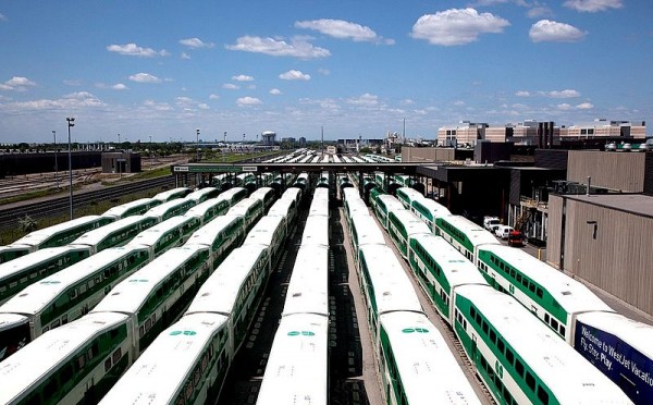
Commuter rail equipment waiting for the evening rush source

Toronto Commuter rail equipment waiting for the evening rush. source

The rail operator in France just started marketing a truly low cost high speed rail option. SNCF will soon start a new rail service under the name OuiGo (yes go! we go!), offering travel as cheap as 10 Euros for travels as far as 500 miles. This may be the cheapest HSR tickets anywhere in the world, and offer quite the competition to low cost air carriers or driving. Just like with the cheap airlines, users may have to deal with some inconveniences: passengers have to pay to bring more bags and to use electrical outlets, there are no cafe cars. And the travel doesn’t start in central Paris, but rather 20km east in Marne La Vallée, to avoid the higher track fees of downtown Paris. That’s similar to how low-cost air carriers offer travel from cheaper outlying airports. Unlike those airlines, though, SNCF is still offering uncompressed seating. 1,268 passengers can fit into the duplex-TGVs by ditching the cafe car and using an all economy layout.

This service got me thinking whether in North America we could have at least cheap medium speed rail options. Both VIA in the Quebec-Windsor corridor and Amtrak in the North-East Corridor offer reasonably fast service, but at prices and with service that appears to attempt competing with air travel. Both Amtrak and VIA neither have the capacity, nor speed to compete with low cost airlines. But they may be able to compete with cars and affordable bus travel offered by Chinatown buses or Megabus.

VIA and Amtrak may not have the equipment to offer afforable high-capacity service. But there’s plenty of rail equipment laying around most of the day that could be used for exactly that — commuter trains. The standard North American commmuter rail paradigm offers service mostly (if not only) during peak hours, dumping large numbers of trains in downtown yards, waiting to rush back to the ‘burbs during the late afternoon. I would prefer they would be used for all day frequent service, but there will always be unused trains during the off-peak. Could they be used to offer affordable intercity service instead of clogging up space downtown?

Let’s check the schedules of two commuter rail lines in Montreal to see when all the trains are really needed. The services use fewer trains than departures, because the earlier trains return back to the origin and do another run. For the Mont St Hilare line, the train arriving at 7:50 in downtown can’t make it back to the end of the line soon enough to be part of the morning rush – it becomes dead weight downtown. Only one train is needed for the midday service. For the evening rush, all trains are used starting with the 16:50 departure. For the Candiac line, there’s one train unused between 8:40 and 16:15. Overall, there are time slots of 7-8 hours during mid-day, and up to 6 hours after 6-7pm, when trains could be used for other duties.

Mont St Hilaire line (55 minutes per run):
arrive downtown: 06:30, 07:25, 07:50, 08:20, 08:50, 14:30, 19:25
depart downtown: 12:30, 15:50, 16:30, 16:50, 17:20, 18:00, 19:45

Candiac Line (40minutes per run):
arrive downtown: 06:40, 07:15, 07:40, 08:17, 08:40, 09:05, 09:30, 11:10, 14:00
depart downtown: 09:35, 12:20, 15:40, 15:55, 16:15, 16:45, 17:15, 17:55, 18:20

Commuter rolling stock may be a good match for high affordable high capacity intercity rail that doesn’t threaten the existing ‘premium’ rail market. It offers less space per passenger, but still much more than cars, buses or aircrafts. There’s also less space for baggage, meaning that it may have to be restricted in some way, just as for the OuiGo service in France. Commuter rail rolling stock offers a large amount of capacity, so even with cheap tickets the service may still be economically feasible. There are few amenities: no cafe cars (although one could install snack vending machines), no outlets (that’s a bummer for laptop carrying students), no wifi.

The cars tend to have lower maximum speed (100mph vs 125mph, or 80mph vs 100mph), so travel times may be slightly longer. This could be offset by having fewer stops, only at larger stations. Not stopping at small towns also matches trying to tap into large travel markets, and not competing too much with existing rail options for smaller markets. With fewer stops, fewer conductors are feasible because there is more time to check tickets between stops.

Travel between 9am and 5pm cut into regular work hours and is thus inconvenient for work-related travel. Travel after 6-7pm, i.e. twoards the end of the evening rush, with arrivals around midnight, may again be somewhat inconvenient for business traveless who may prefer taking intercity trains towards the beginning of the evening rush, in order to arrive during more reasonable times.

Schedule possibilities
A 7-8hour mid-day time slot allows for travel back and forth in the 2.5 to 3.5 hour range. Along the Quebec Windsor Corridor, this could match city paris like Montreal-Quebec, Montreal-Ottawa, Montreal-Kingston, Toronto-Kingston, Toronto-London. In the US, Philadelphia-New York, Philadelphia-DC and New York-Albany are easily doable, other city pairs will take longer than 4 hours.

In order to connect better city pairs that are more than 4 hours apart like New York-Dc, Montreal-Toronto, and Boston-New York, all of which have compatible commuter rail operations, one could send a train from each city to the other during the mid-day. The two trains could be used in the evening rush service at the destination city, for a sort of away game. The trains could then return either after the rush hour for a late night return, or during the next day. Equipment should be available during the whole weekend, allowing even more departures.

A note about non-main station departures: Gare Centrale in Montreal uses high-level platforms, which Toronto’s bilevel commuter cars can’t access. But the existing commuter rail stations of Vendome and Lucien L’Allier in Montreal are low platform, not far from downtown, and connected via the metro. In New York, there may be capacity issues going through the Hudson tunnels that connect Manhattan and New Jersey. If it’s impossible to add train departures even during mid-day, it may still be possible to have the trains depart from a New Jersey location that is accessible by rapid transit (i.e. Hoboken or Newark).

514 Buses –
get Montreal bus schedules via cell phone

Tuesday, October 11th, 2011

Warning: I am currently transitioning this app to a new format so the schedules are not up to date (as of 2013). When I built the app, it relied on scraping the data from the STM's website, a painful process. I am now migrating to their GTFS feed, which will take some time.

If you are one of the two thirds of Canadian cell phone users who do not have a smart phone, you might find yourself late at night at a bus stop, waiting a very long time for the next bus home. If you had a smart phone with a Google maps app or the new STM app, you would probably have checked when the next bus comes, and waited longer inside that warm bar, or at the party where you were.

Sure, you could get the paper flyers of the relevant bus schedules, if you know where to get them, but it's still all very cumbersome. You could also use the phone service of the STM, telling you the next buses for one given stop. But it will only tell you the schedule if you know the 5-digit stop number and bus line - and you'll only find those once you are at the stop, so you still gotta wait there. And you won't find out about other nearby lines and stops.

So at last weekend's Back to School Hackathon, I thought it would be a good idea to try to make life a bit easier for those of us who still have that dumb phone, and developed a simple sms-based application that will tell you the next buses near a given address. You can just text your current address, intersection, postal code or point of interest to

514-600-1287 (that's 514-6001-BUS)***

and it will find nearby bus stops, and give the next scheduled departures.


Try the web-version:
address:


As you can see, the app returns a very compact result**:

  • At the top it shows the time relative to which the schedule is displayed
  • It will show a compact name for each bus stop, with the distance (in metres) from your supplied address
  • for each bus stop, it will show the buses, together with their direction (W,E,S,N), and the next couple of buses, in minutes relative to the displayed time

The app properly deals with weekend days, holidays, night buses. It will also deal with special characters that show up in the original schedule (">" or "+"). They will be displayed, and usually mean that the bus is taking some alternate route. The system knows 96% of the bus stops (although some might be located incorrectly). and supports the following options:

  • the first word can be set of option characters. W, E, S, N will display only buses in the supplied direction, H will display wheelchair accessible buses using '*'. Multiple characters can be used in one word. Example: "WEH 688 Sherbrooke" will show all westbound and eastbound buses, and show handicapped access.
  • You can add a trailling "in number", where the number is in minutes. This will provide the schedules relative to a time in the future. Example: "h3a 2t5 in 30" will show buses near postal code H3A 2T5 in 30 minutes.

This application, given the 160 character limitation, naturally does no actual routing. It just gives scheduled departures. You still have to know your lines. This fits the idea that many people do know the routes of buses that are relevant to them, even if their don't know the schedules. This complements the idea of the frequent service network - you know how to get there, but you would like some independence regarding schedules. By making this an sms app rather than a smart phone app, I hope for this to be useful to more people.

Some argue that smartphones are not a game changer for transit. But tools like this should help reduce some of the stress associated with taking buses - the wait at the stop - and maybe will make some travelling a bit more enjoayble.


disclaimer: This is currently beta. The phone number may change. The phone system may not respond at times (in which case try resending your request).

**Update: Due to a recent outage at tropo, the sms service, I changed the system to respond via another service, twilio. So the system will now respond with a different number (which should also accept requests - but it is a US number). Along with this change the format of the response changed to show absolute times rather than relative times.
***Update: After the service called twilio started offering canadian phone numbers with sms support, I have switched over the service to this new number. The old number ((514) 418-0428), should still work for a while.
****Update: As per the warning above, the schedules are out of date.

A Map for Montréal’s frequent service

Thursday, September 2nd, 2010

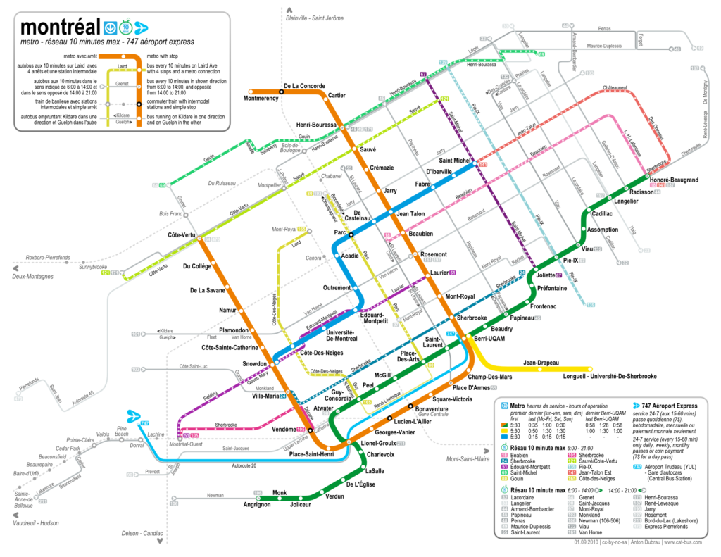
As mentioned in a previous post, I've been working on a frequent service map of Montreal's new réseau 10 minute max (10 minute network). Just a couple of days after the new schedule went on effect on August 30th, I am now publishing this map (under cc-by-sa-nc).

The stm also published a map. But theirs is basically just the full system map with the whole system (except the metro) removed and the frequent lines added in thick lines -- it's still a huge map (because it is geographically accurate), for a relatively simple system. Also, the lines often sit on top of the metro lines, so it's hard to read.

I wanted to make a map that is similarly abstract as the old metro map, to show the similarity between the frequent service network and the metro system itself. Both should be accessible without needing any schedules, or knowing the area well where one is travelling. I wanted to combine the simplicity of the traditional tube map with the look and feel of the Montreal metro map (and the new stm designs) while adding in the frequent bus lines - and all that in a letter format.

The result is indeed letter sized (with 5mm margins), and designed to fold twice (along the legend boxes), albeit with some pretty small fonts. Nevertheless, it should be possible to carry this map along all journeys much more easily than the whole system map -- this independence is sort of the intent of the original London tube map, and also of the new frequent service network.

I added the commuter train stations on the island of Montreal, something that the metro map doesn't show. Although they don't run frequently, the connections are good to know and an imprtant aspect of the public transportation network -- so they are shown in greyed out, dotted lines. I also added the airport express bus, even though it runs at a lower frequency than 10 minutes, because of it's success and general importance. The legend shows that it runs less often.

The stm chose a system of 11 lines with 10-minute frequent service running form 6am to 9pm, and a set of 19 lines that run frequent in the downtown direction from 6am to 2pm, and in the opposite between 2pm and 9pm. These lines don't qualify as all-day frequent service, so they are also shown greyed out, with arrows indicating the morning/downtown direction. I assigned colors to the all-day frequent lines as if they were metro lines, based on the sort of pastell color theme of the stm.

A feature that is not even in the full system map is the indication of all stops along the bus lines. While I didn't actually name any, it still provides useful information - it gives an indication of how long it takes to traverse a certain route (the more stops the longer it takes), and it gives an idea of how many stops it takes to go from one intersection to another. The one should help people to be more independent of schedules by being able go estimate how long a trip will take, and the other helps people to navigate the city riding the bus without knowing a certain area. Both are intended to lower the barrier of entry for new users (or users new to an area, or tourists) to be able to use the bus system. A focus on usability in public transport systems (especially buses) is sometimes lacking, but attempting to create user experience similar to a metro system should help attracting riders.

A 600 dpi version can be found here. And a pdf. Or the svg. (update: I correct errors only on these files.)

This project was partly inspired by Jarret Walkers treatment of frequent service ideas over at human transit. Most of the above links direct to his discussions of the topic. I have also taken a closer look at the bus network.

Check out the most recent update.

Towards a frequent Network Map for Montréal

Tuesday, August 24th, 2010
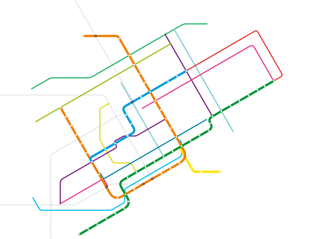
As posted in Montréalités urbaine and human transit, Montréal now has a frequent network brand. It's called Réseau 10 Minutes max. Jarret at Human Transit has been making the case for frequent transit maps for a while now. The idea is that bus service that runs at high frequency should be marked differently from other bus service, because these lines allow us to travel without looking up any schedule. In this way they are similar to rapid transit (like the metro); we only need a map to plan our journey. And some people tend to memorize them so they don't need any map at all to make basic travel plans through their city. Montreals Réseau 10 Minutes max includes 11 lines with all day frequent service, and another 20 which have frequent service in one direction until 2pm, and frequent service in the other direction afterwards. This service has to run all day at high frequency, otherwise there is no sense of reliability (i.e. not needing a schedule), and the lines are frequent from 6am to 9pm. Inspired by Jarrets blog I have been planning to make a frequent network map based on existing schedules. But the STM was quicker than me, and with their new label saved me the work of scraping all their bus schedules and deciding which service could be considered frequent -- problematic because the STM generally does not seem to believe in fixed interval schedules, so service that is really frequent during some points during the day might be very infrequent at others. In a way this service represents a shift of paradigms away from schedules that are exactly modeled by demand, and towards service that is more easily memorized and can be more easily relied upon. The actual improvement in service might actually be fairly small and mostly during times many people don't travel anyway; but it can create a powerful brand if it is marketed right. That's why it is surprising that there has been very sparse information about it so far, although the schedule is to take effect on August 30th. In particular, there is no map yet. Which leaves me to make a map after all. The shown image is the first draft, showing all metro lines and the all day frequent services, as well as the commuter rail (dotted). I opted for a very abstract view, compatible with the existing metro map and the new corporate design of the STM. With all the names and dots missing, in this minimalistic state, I find the map kind of appealing. But more info should really be added to make it actually useful, and I hope to add
  • The 20 one-way-frequent lines (grayed out because they are less reliable)
  • The names of the streets the buses are running on
  • Dots for intersections
  • Possibly little dots denoting every stop -- they are a measure of how fast a service is (many stops make a bus slow)
  • A legend
It's not clear whether it's better to mark the streets busses are running on by labelling intersecting lines, or simply be putting the name of the street along every line. Also there is the problem of how to mark the direction of frequency. Thoughts are appreciated.

Suburban Missed Connection:
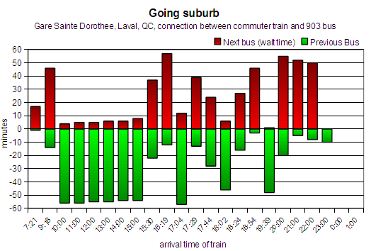
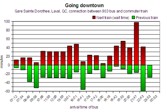
Train4Bus – When I arrived, you had just left

Tuesday, August 17th, 2010
One of the problems of transit is topography. How can you provide good transit service where the population density is too low? Ideally one would want good service throughout the network, but of course that's not affordable. On the other hand these areas still need access to public transportation. So there will always be a fair amount of transit service running at low frequency. But how can you get people to switch from cars to transit (or more importantly, not switch from transit to cars) if you cannot provide frequent service? Most people will not take the bus to save the planet, but they will if it provides similar (or better) mobility as the car. One way to lose riders to the car is by not providing timed connections. Many services in low density areas are actually feeder lines to more frequent lines, rapid transit lines or commuter trains. If a connection can not be ensured, then the transit agency will lose riders. This seems really obvious, but it's something that some transit agencies fail to enforce consistently, especially across different agencies. Case in point: recently a friend of mine bought herself a house and moved into the suburb city of Laval, just north of Montreal. Naturally I asked her how she gets downtown for work (who wouldn't?), and to my relief I found out she takes the commuter train. She did complain about the bad connection to the bus, which supposedly makes her wait for an hour at the train station all the time -- both the train and the bus are infrequent; they come about hourly. It turns out that the bus often leaves a couple of minutes before the train arrives. This is especially true when going home in the evening. The only short connection during the whole evening is exactly 1 minute, so it's likely that a passenger will still be stranded for an hour. The bus and the train both come about hourly, and the bus has its terminus there, meaning that the connection is important for that line. The graph shows, for every train arrival, when the next bus will arrive and also when the previous bus left. Ideally the connection should always be like in the morning. The other way the wait is not quite as long, but it seems the bus is scheduled to arrive half-way between the trains. To illustrate the issue, it takes the commuter train 30 minutes to get to the suburb station, and the bus another 10 to bring my friend home. If the layover would be 5 minutes, this would mean 45 minutes of travel time (plus some walking). With a 52 minute layover, the travel time is now 92 minutes - more than twice as long. If you assume that the perceived time of waiting is 2.5x the actual time, then going home feels like 170 minutes... This sort of scheduling problem is not just a fluke, it's an example of a larger problem in the Montreal area. According to a recent article in the Montreal Gazette, up to 19 transit authorties and regional/municipal bodies are involved in planning. Additionally, Aéroports de Montreal, which runs the Trudeau airport, is pushing it's own transit agenda to create a non stop rail shuttle to downtown. Currently it looks like their option is going to be chosen, rather than the more integrated plan of the AMT (agence metropolitaine de transport) to create a surface metro in the badly served West Island. With all these agencies, it is no wonder that there are issues with planning, fare zones, and, well, scheduling. Bad schedules in particular are mostly due to organizational issues, not due to lack of actual transit resources. These issues could be solved with more cooperation, without actually having to increase service. For such infrequent service, schedules make or break the whole transit network. And it is supposed to be a network, not just a set of badly connected infrequently served lines. I wonder how many more connections are this bad, and whether an individual can do anything to get this fixed. But in the meantime my friend is being pushed into using the car by transit agencies that do not cooperate.